


Route des Roches. Schlucht-Hohneck

janussity
User
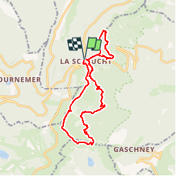

Length
15.6 km

Max alt
1351 m

Uphill gradient
769 m
Km-Effort
26 km

Min alt
940 m

Downhill gradient
772 m
Boucle
Yes
Creation date :
2019-06-30 06:06:00.112
Updated on :
2019-07-05 12:43:08.402
6h30
Difficulty : Difficult

FREE GPS app for hiking
 SityTrail
IGN / Geographical institutes
SityTrail Plus
The world is yours!
About
Trail Walking of 15.6 km to be discovered at Grand Est, Vosges, Le Valtin. This trail is proposed by janussity.
Description
Chaud. venteux. Ensoleillé
Photos


23 photos in total. Please click on a photo to see them all in the gallery.
Positioning
Country:
France
Region :
Grand Est
Department/Province :
Vosges
Municipality :
Le Valtin
Location:
Unknown
Start:(Dec)
Start:(UTM)
352648 ; 5325335 (32U) N.
Comments